
Thank you for supporting this site ❤️
Make a donation
Make a donation
Gear up for your next adventure:
As an Amazon Associate, this site earns from qualifying purchases at no extra cost to you.
Gimcheon-si topographic map
Click on the map to display elevation.
Thank you for supporting this site ❤️
Make a donation
Make a donation
Gear up for your next adventure:
🧦Merino Wool Hiking Socks - Moisture-wicking socks to prevent blisters during long topographic surveys
As an Amazon Associate, this site earns from qualifying purchases at no extra cost to you.
About this map
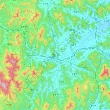
Name: Gimcheon-si topographic map, elevation, terrain.
Location: Gimcheon-si, North Gyeongsang, 39547, South Korea (35.97980 127.95395 36.29980 128.27395)
Average elevation: 263 m
Minimum elevation: 34 m
Maximum elevation: 1,156 m
Thank you for supporting this site ❤️
Make a donation
Make a donation
Gear up for your next adventure:
As an Amazon Associate, this site earns from qualifying purchases at no extra cost to you.