
Make a donation
Gear up for your next adventure:
As an Amazon Associate, this site earns from qualifying purchases at no extra cost to you.
Tilburg topographic map
Click on the map to display elevation.
Make a donation
Gear up for your next adventure:
As an Amazon Associate, this site earns from qualifying purchases at no extra cost to you.
Tilburg
In the 1980s, many locations, formerly occupied by wool factories had been filled with small-scale housing projects. This mostly happened when Henk Letschert was mayor of Tilburg. The Heuvel, one of the important squares, had its own lime tree until 27 April 1994, being chopped for a bicycle parking basement. The felling led to many protests, because the tree was still healthy. After the Pieter Vreedeplein reconstruction, plans were made to plant a descendant of the original lime tree. Three were placed, only one of them survived. The last living tree was moved to another location again, but died shortly after. As of 23 November 2011, no more descendants have been placed. The current one is just another lime tree. In the 1990s Tilburg developed a modern skyline. Because of new policy three buildings were built, which are considered skyscrapers in the Netherlands. These are the Interpolis headquarters, the Westpoint Tower and StadsHeer. The Westpoint Tower has an altitude of 143.1 metres (469.5 feet) and was the tallest residential tower in The Netherlands until the Montevideo in Rotterdam surpassed it. The 'StadsHeer' is the third one and is part of the 'Haestrechtkwartier' (Haestrecht quarter). The residential tower is nicknamed De Vogelkooikes (The Bird Cages) for its cubic balconies taped onto the building.
Make a donation
Gear up for your next adventure:
As an Amazon Associate, this site earns from qualifying purchases at no extra cost to you.
About this map
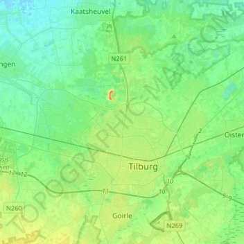
Name: Tilburg topographic map, elevation, terrain.
Location: Tilburg, North Brabant, Netherlands (51.52950 4.94785 51.64166 5.21071)
Average elevation: 11 m
Minimum elevation: -1 m
Maximum elevation: 38 m
Make a donation
Gear up for your next adventure:
As an Amazon Associate, this site earns from qualifying purchases at no extra cost to you.
Other topographic maps
Click on a map to view its topography, its elevation and its terrain.
Make a donation
Gear up for your next adventure:
As an Amazon Associate, this site earns from qualifying purchases at no extra cost to you.
Make a donation
Gear up for your next adventure:
As an Amazon Associate, this site earns from qualifying purchases at no extra cost to you.
Make a donation
Gear up for your next adventure:
As an Amazon Associate, this site earns from qualifying purchases at no extra cost to you.
Make a donation
Gear up for your next adventure:
As an Amazon Associate, this site earns from qualifying purchases at no extra cost to you.
Make a donation
Gear up for your next adventure:
As an Amazon Associate, this site earns from qualifying purchases at no extra cost to you.
Make a donation
Gear up for your next adventure:
As an Amazon Associate, this site earns from qualifying purchases at no extra cost to you.