Słupca County topographic map
Click on the map to display elevation.
About this map

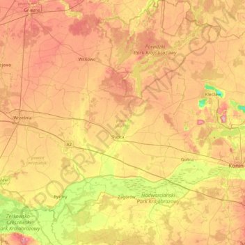
Name: Słupca County topographic map, elevation, terrain.
Location: Słupca County, Greater Poland Voivodeship, Poland (52.07338 17.68343 52.55503 18.13362)
Average elevation: 100 m
Minimum elevation: 33 m
Maximum elevation: 166 m
Other topographic maps
Click on a map to view its topography, its elevation and its terrain.

Kaźmierz
Poland > Greater Poland Voivodeship > Szamotuły County
Kaźmierz, gmina Kaźmierz, Szamotuły County, Greater Poland Voivodeship, 64-530, Poland
Average elevation: 88 m

Koło County
Poland > Greater Poland Voivodeship
Koło County, Greater Poland Voivodeship, Poland
Average elevation: 113 m

Ostrów Wielkopolski
Poland > Greater Poland Voivodeship > Ostrów Wielkopolski County
Ostrów Wielkopolski, Ostrów Wielkopolski County, Greater Poland Voivodeship, 63-400, Poland
Average elevation: 140 m

Poznań
Poland > Greater Poland Voivodeship
Poznań, Greater Poland Voivodeship, Poland
Average elevation: 85 m

Szamotuły County
Poland > Greater Poland Voivodeship
Szamotuły County, Greater Poland Voivodeship, Poland
Average elevation: 81 m

Adamin
Poland > Greater Poland Voivodeship
Adamin, gmina Olszówka, powiat kolski, Greater Poland Voivodeship, 62-641, Poland
Average elevation: 107 m

Kotunia
Poland > Greater Poland Voivodeship > Słupca County
Kotunia, gmina Słupca, Słupca County, Greater Poland Voivodeship, 62-400, Poland
Average elevation: 90 m