Geolocate

Hungerford topographic map

Interactive map

Click on the map to display elevation.

About this map

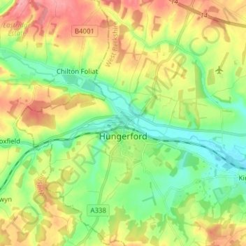
Name: Hungerford topographic map, elevation, terrain.

Location: Hungerford, West Berkshire, England, United Kingdom (51.37758 -1.57119 51.45585 -1.47284)

Average elevation: 131 m

Minimum elevation: 89 m

Maximum elevation: 191 m

Other topographic maps

Click on a map to view its topography, its elevation and its terrain.

Newbury

United Kingdom > England > West Berkshire

Newbury, West Berkshire, England, United Kingdom

Average elevation: 97 m

West Woodhay

United Kingdom > England > West Berkshire > West Woodhay

West Woodhay, West Berkshire, South East England, England, United Kingdom

Average elevation: 158 m