
Beek topographic map
Click on the map to display elevation.
Beek
The municipality of Beek makes part of the region of South Limburg and lies between the city of Geleen in the north and Maastricht in the south, and lies furthermore southeast of interchange Kerensheide and the chemical industries of Chemelot. It has a slightly hilly landscape with altitudes differing between 70 and 120 metres (230 and 390 ft) above sea level, and has two small forests: Kelmonderbos between Beek and Kelmond, and Spaubekerbos near Spaubeek. The Keutelbeek flows through and has its source in the municipality of Beek.
About this map
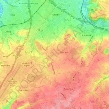
Name: Beek topographic map, elevation, terrain.
Location: Beek, Limburg, Netherlands (50.89855 5.75485 50.95514 5.85693)
Average elevation: 102 m
Minimum elevation: 44 m
Maximum elevation: 143 m
Other topographic maps
Click on a map to view its topography, its elevation and its terrain.