
Deer Park topographic map
Interactive map
Click on the map to display elevation.
About this map
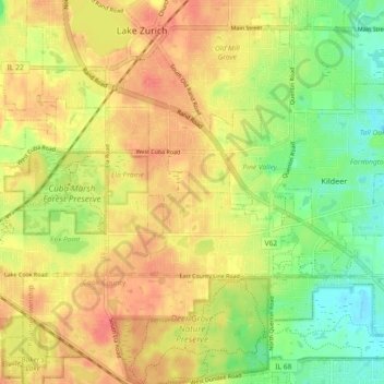
Name: Deer Park topographic map, elevation, terrain.
Location: Deer Park, Lake County, Illinois, United States (42.15211 -88.12955 42.18501 -88.03867)
Average elevation: 253 m
Minimum elevation: 223 m
Maximum elevation: 276 m
Other topographic maps
Click on a map to view its topography, its elevation and its terrain.
Kings Island
United States > Illinois > Lake County > Fox Lake
Kings Island, Fox Lake, Lake County, Illinois, 60020, United States
Average elevation: 229 m
James Creek Estates
United States > Illinois > Lake County > Waukegan
James Creek Estates, Waukegan, Lake County, Illinois, 60087, United States
Average elevation: 204 m
Grayslake
United States > Illinois > Lake County > Grayslake
Grayslake, Lake County, Illinois, 60030, United States
Average elevation: 241 m
Yeet Pond
United States > Illinois > Lake County > Vernon Hills
Yeet Pond, CENTENNIAL CROSSING, Vernon Hills, Lake County, Illinois, United States
Average elevation: 212 m
Bannockburn
United States > Illinois > Lake County
Bannockburn, Lake County, Illinois, United States
Average elevation: 206 m