Geolocate

Parauapebas topographic map

Click on the map to display elevation.

About this map
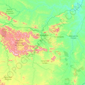
Name: Parauapebas topographic map, elevation, terrain.

Location: Parauapebas, Região Geográfica Imediata de Parauapebas, Região Geográfica Intermediária de Marabá, Pará, North Region, 68515-000, Brazil (-6.54390 -51.19898 -5.85352 -49.73247)

Average elevation: 250 m

Minimum elevation: 83 m

Maximum elevation: 878 m

Other topographic maps

Click on a map to view its topography, its elevation and its terrain.
Rio Grande

Brazil > Pará > Curuçá

Average elevation: 15 m

Amazon River

Brazil > Pará > Almeirim

Average elevation: 17 m

Maipu

Brazil > Pará > Araguaia River

Average elevation: 312 m

Gear up for your next adventure:

🪢550 Survival Paracord - Versatile cordage for gear repair and emergency lashing
📕Hiking Guide Books - Guides for hiking trails
🏕️Camping Gear - Essential camping equipment
⌛Survival Blankets - Emergency thermal blankets
🎨Portable Watercolor Kits - Paint the landscapes and topographic views you discover

As an Amazon Associate, this site earns from qualifying purchases at no extra cost to you.