
León topographic map
Interactive map
Click on the map to display elevation.
About this map
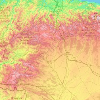
Name: León topographic map, elevation, terrain.
Location: León, Castile and León, Spain (42.02928 -7.07707 43.23820 -4.73236)
Average elevation: 913 m
Minimum elevation: 0 m
Maximum elevation: 2,527 m
As for the temperatures, in general it is a cold climate due to the altitude and the abundance of frost (which persist from November to May), being more intense in the mountainous areas reaching -18 °C. Vega de Liordes, an enclave in the León sector of Picos de Europa belonging to the municipality of Posada de Valdeón registered −35.8 °C (−32.4 °F) on January 7, 2021.
Other topographic maps
Click on a map to view its topography, its elevation and its terrain.
Mijares
Mijares, Ávila, Castile and León, 05461, Spain
Average elevation: 932 m
Guimares
Spain > Castile and León > Gallegos del Río
Guimares, Domez de Alba, Gallegos del Río, Zamora, Castile and León, Spain
Average elevation: 744 m
Ponferrada
Spain > Castile and León > El Bierzo
Ponferrada, El Bierzo, León, Castile and León, Spain
Average elevation: 883 m
Espinosa de los Monteros
Spain > Castile and León > Espinosa de los Monteros
Espinosa de los Monteros, Burgos, Castile and León, Spain
Average elevation: 919 m
Los Santos
Spain > Castile and León > Los Santos
Los Santos, Salamanca, Castile and León, 37768, Spain
Average elevation: 936 m
El Yuste
Spain > Castile and León > El Hoyo de Pinares
El Yuste, El Hoyo de Pinares, Ávila, Castile and León, Spain
Average elevation: 959 m
Villares de la Reina
Spain > Castile and León > Villares de la Reina
Villares de la Reina, Salamanca, Castile and León, Spain
Average elevation: 820 m
Riaño
Spain > Castile and León > Riaño
Riaño, Castile and León, 24900, Spain
Average elevation: 1,140 m
La Tala
Spain > Castile and León > La Tala
La Tala, Guijuelo, Castile and León, Spain
Average elevation: 946 m
Arapiles
Arapiles, Salamanca, Castile and León, Spain
Average elevation: 842 m
San Justo
Spain > Castile and León > San Justo
San Justo, Galende, Castile and León, Spain
Average elevation: 1,332 m
Buenavista
Buenavista, Guijuelo, Castile and León, 37789, Spain
Average elevation: 936 m
La Maya
Spain > Castile and León > La Maya
La Maya, Tierra de Alba, Salamanca, Castile and León, Spain
Average elevation: 850 m
Roa
Spain > Castile and León > Roa
Roa, Ribera del Duero, Burgos, Castile and León, Spain
Average elevation: 835 m
Calatañazor
Spain > Castile and León > Calatañazor
Calatañazor, Comarca de Soria, Soria, Castile and León, 42193, Spain
Average elevation: 1,092 m
Palencia
Spain > Castile and León > Palencia
Palencia, Castile and León, Spain
Average elevation: 794 m
El Pipón
Spain > Castile and León > Almarza
El Pipón, Almarza, El Valle, Soria, Castile and León, 42164, Spain
Average elevation: 1,145 m
Atua
Spain > Castile and León > Condado de Treviño
Atua, Condado de Treviño, Miranda de Ebro, Castile and León, Spain
Average elevation: 629 m
Contreras
Spain > Castile and León > Contreras
Contreras, Sierra de la Demanda, Burgos, Castile and León, Spain
Average elevation: 1,089 m
Pico Almanzor
Spain > Castile and León > Candeleda
Pico Almanzor, Candeleda, Comarca de Arenas de San Pedro, Ávila, Castile and León, Spain
Average elevation: 2,159 m
Cantagallo
Spain > Castile and León > Cantagallo > Cantagallo
Cantagallo, Béjar, Castile and León, Spain
Average elevation: 996 m