
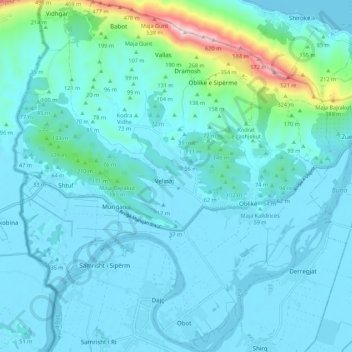
Ana e Malit topographic map
Interactive map
Click on the map to display elevation.
About this map
Name: Ana e Malit topographic map, elevation, terrain.
Average elevation: 76 m
Minimum elevation: -4 m
Maximum elevation: 637 m
Other topographic maps
Click on a map to view its topography, its elevation and its terrain.
Theth
Albania > Northern Albania > Shkodër County > Shalë
Theth, Shalë, Shkodër Municipality, Shkodër County, Northern Albania, 4009, Albania
Average elevation: 1,112 m
Pog
Albania > Northern Albania > Shkodër County > Pult
Pog, Pult, Shkodër Municipality, Shkodër County, Northern Albania, 4010, Albania
Average elevation: 712 m
Shkoder
Albania > Northern Albania > Shkodër County > Shkoder
Shkoder, Shkodër, Shkodër Municipality, Shkodër County, Northern Albania, 4001-4007, Albania
Average elevation: 164 m