
Mossyrock topographic map
Interactive map
Click on the map to display elevation.
About this map
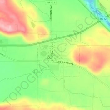
Name: Mossyrock topographic map, elevation, terrain.
Location: Mossyrock, Lewis County, Washington, United States (46.52537 -122.49166 46.53567 -122.47544)
Average elevation: 213 m
Minimum elevation: 133 m
Maximum elevation: 303 m
Other topographic maps
Click on a map to view its topography, its elevation and its terrain.
Wilson
United States > Washington > Lewis County
Wilson, Lewis County, Washington, United States
Average elevation: 358 m