
Snailbeach topographic map
Interactive map
Click on the map to display elevation.
About this map
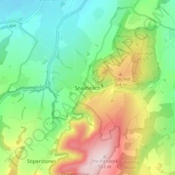
Name: Snailbeach topographic map, elevation, terrain.
Location: Snailbeach, Shropshire, England, SY5 0NX, United Kingdom (52.59381 -2.94663 52.63381 -2.90663)
Average elevation: 248 m
Minimum elevation: 105 m
Maximum elevation: 498 m
Other topographic maps
Click on a map to view its topography, its elevation and its terrain.
Shrewsbury
United Kingdom > England > Shropshire
Shrewsbury, Shropshire, England, United Kingdom
Average elevation: 69 m
Stanton Lacy
United Kingdom > England > Shropshire
Stanton Lacy, Shropshire, England, United Kingdom
Average elevation: 137 m
Hanwood Bank
United Kingdom > England > Shropshire > Hanwood
Hanwood Bank, Great Hanwood, Hanwood, Shropshire, England, SY5 8NF, United Kingdom
Average elevation: 92 m
Obley
United Kingdom > England > Shropshire > Clunbury
Obley, Clunbury, Shropshire, England, SY7 0BZ, United Kingdom
Average elevation: 310 m
Wooton
United Kingdom > England > Shropshire
Wooton, Oswestry Rural, Shropshire, England, SY11 4LH, United Kingdom
Average elevation: 90 m
Newnes
United Kingdom > England > Shropshire > Ellesmere > Newnes
Newnes, Ellesmere Rural, Ellesmere, Shropshire, West Midlands, England, SY12 9HH, United Kingdom
Average elevation: 101 m