Geolocate

St. Agnes topographic map

Click on the map to display elevation.

About this map

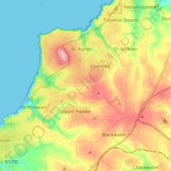
Name: St. Agnes topographic map, elevation, terrain.

Location: St. Agnes, Cornwall, England, United Kingdom (50.25517 -5.25217 50.33508 -5.15979)

Average elevation: 78 m

Minimum elevation: 0 m

Maximum elevation: 187 m

Other topographic maps

Click on a map to view its topography, its elevation and its terrain.

Darite

United Kingdom > England > Cornwall > St Cleer

Average elevation: 236 m

Pengold

United Kingdom > England > Cornwall > St Gennys

Average elevation: 135 m

Port Isaac

United Kingdom > England > Cornwall

Average elevation: 43 m

Gunnislake

United Kingdom > England > Cornwall

Average elevation: 109 m

Bridgetown

United Kingdom > England > Cornwall

Average elevation: 93 m

Pengrugla

United Kingdom > England > Cornwall > Pengrugla

Average elevation: 66 m

Minions

United Kingdom > England > Cornwall > Minions

Average elevation: 265 m

Gwinear

United Kingdom > England > Cornwall

Average elevation: 65 m

Lerryn

United Kingdom > England > Cornwall

Average elevation: 60 m

Gear up for your next adventure:

🖼️Scratch-off Australia Map - Track the regions and peaks you have explored geographically
🦟Heavy Duty Insect Repellent - Essential protection against flies, mozzies, and march flies
🕯️Emergency Whistles - Safety whistles for hiking
🩹First Aid Kits - Emergency kits for hiking
🎒3L Hydration Reservoirs - Hands-free drinking to stay hydrated on steep contour climbs

As an Amazon Associate, this site earns from qualifying purchases at no extra cost to you.