
Make a donation
Gear up for your next adventure:
As an Amazon Associate, this site earns from qualifying purchases at no extra cost to you.
Jönköping topographic map
Click on the map to display elevation.
Make a donation
Gear up for your next adventure:
As an Amazon Associate, this site earns from qualifying purchases at no extra cost to you.
Jönköping
Between 1961 and 1990, Jönköping's climate was humid continental (Köppen Dfb) with long, cold winters and short, warm summers. However, the window between subarctic and oceanic is very small in this marine-influenced climate type, and in recent years the climate has more resembled very cold oceanic. Figures are slightly skewed because the weather station is at the airport, which is at an elevation of 228 metres (748 ft); the city centre is at 100 metres (330 ft). Temperatures in the urban centre are likely milder, with a difference between half a degree and a full degree.
Make a donation
Gear up for your next adventure:
As an Amazon Associate, this site earns from qualifying purchases at no extra cost to you.
About this map
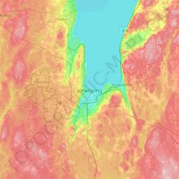
Name: Jönköping topographic map, elevation, terrain.
Location: Jönköping, Jönköpings kommun, Jönköping County, 551 86, Sweden (57.62256 14.00572 57.94256 14.32572)
Average elevation: 215 m
Minimum elevation: 86 m
Maximum elevation: 350 m
Make a donation
Gear up for your next adventure:
As an Amazon Associate, this site earns from qualifying purchases at no extra cost to you.
Other topographic maps
Click on a map to view its topography, its elevation and its terrain.
Make a donation
Gear up for your next adventure:
As an Amazon Associate, this site earns from qualifying purchases at no extra cost to you.
Make a donation
Gear up for your next adventure:
As an Amazon Associate, this site earns from qualifying purchases at no extra cost to you.
Make a donation
Gear up for your next adventure:
As an Amazon Associate, this site earns from qualifying purchases at no extra cost to you.