
Make a donation
Gear up for your next adventure:
As an Amazon Associate, this site earns from qualifying purchases at no extra cost to you.
Larissa topographic map
Click on the map to display elevation.
Make a donation
Gear up for your next adventure:
As an Amazon Associate, this site earns from qualifying purchases at no extra cost to you.
About this map
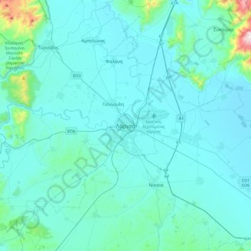
Name: Larissa topographic map, elevation, terrain.
Average elevation: 128 m
Minimum elevation: 47 m
Maximum elevation: 1,073 m
Make a donation
Gear up for your next adventure:
As an Amazon Associate, this site earns from qualifying purchases at no extra cost to you.
Other topographic maps
Click on a map to view its topography, its elevation and its terrain.
Elassona Municipality
Greece > Thessaly and Central Greece > Larisa Regional Unit
Its geography includes farmlands in the valley areas, the mountains to the west and east and forests in the west and east as well as grasslands, ledges are to be founded in some areas and barren area in the higher elevations.
Average elevation: 644 m
Farsala Municipality
Greece > Thessaly and Central Greece > Larisa Regional Unit
The Pharsalos of the historic era was built over a hillside of the Narthacius mountains at an elevation of some 160 m, where modern Farsala stands. It was one of the main cities in Thessaly and was the capital of the Phthian tetrarch. It was also a polis (city-state).
Average elevation: 292 m