
Thank you for supporting this site ❤️
Make a donation
Make a donation
Gear up for your next adventure:
As an Amazon Associate, this site earns from qualifying purchases at no extra cost to you.
Marion Center topographic map
Click on the map to display elevation.
Thank you for supporting this site ❤️
Make a donation
Make a donation
Gear up for your next adventure:
As an Amazon Associate, this site earns from qualifying purchases at no extra cost to you.
About this map
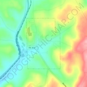
Name: Marion Center topographic map, elevation, terrain.
Location: Marion Center, Indiana County, Pennsylvania, United States (40.76284 -79.05406 40.77860 -79.04008)
Average elevation: 428 m
Minimum elevation: 378 m
Maximum elevation: 504 m
Thank you for supporting this site ❤️
Make a donation
Make a donation
Gear up for your next adventure:
📣High-Decibel Survival Whistles - Signaling tool for rescue that carries much further than a human voice
As an Amazon Associate, this site earns from qualifying purchases at no extra cost to you.
Other topographic maps
Click on a map to view its topography, its elevation and its terrain.
Fairfield Heights
United States > Pennsylvania > Indiana County > Burrell Township
Average elevation: 396 m