
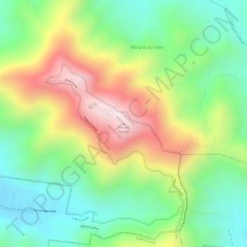
Mount Archer topographic map
Interactive map
Click on the map to display elevation.
About this map
Name: Mount Archer topographic map, elevation, terrain.
Average elevation: 299 m
Minimum elevation: 83 m
Maximum elevation: 592 m
Other topographic maps
Click on a map to view its topography, its elevation and its terrain.
Capricorn Coast National Park
Australia > Queensland > Rockhampton
Capricorn Coast National Park, Svendson Road, Zilzie, Rockhampton, Queensland, 4710, Australia
Average elevation: 12 m
Constitution Hill
Australia > Queensland > Rockhampton
Constitution Hill, Rockhampton, Queensland, Australia
Average elevation: 104 m
Mount Archer National Park
Australia > Queensland > Rockhampton
Mount Archer National Park, Zamia Walk, Mount Archer, Rockhampton, Queensland, Australia
Average elevation: 193 m
The Keppels
Australia > Queensland > Rockhampton
The Keppels, Rockhampton, Queensland, Australia
Average elevation: 7 m
Keppel Bay Islands National Park
Australia > Queensland > Rockhampton
Keppel Bay Islands National Park, Rockhampton, Queensland, Australia
Average elevation: 25 m
Etna Creek
Australia > Queensland > Rockhampton
Etna Creek, Rockhampton, Queensland, Australia
Average elevation: 34 m
w
Australia > Queensland > Rockhampton
w, Kalapa, Rockhampton Regional, Queensland, Australia
Average elevation: 170 m
Keppel Bay
Australia > Queensland > Rockhampton
Keppel Bay, Rockhampton, Queensland, Australia
Average elevation: 0 m
Tungamull
Australia > Queensland > Rockhampton
Tungamull, Rockhampton, Queensland, Australia
Average elevation: 55 m
Mount Hay
Australia > Queensland > Rockhampton
Mount Hay, Rockhampton, Queensland, Australia
Average elevation: 137 m