Geolocate

Damascus topographic map

Click on the map to display elevation.

About this map

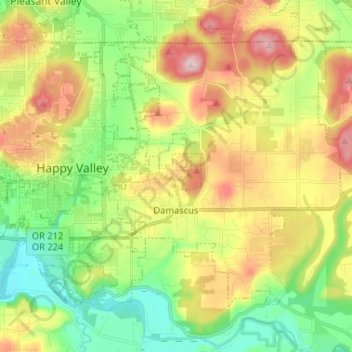
Name: Damascus topographic map, elevation, terrain.

Location: Damascus, Clackamas County, Oregon, 97089, United States (45.39154 -122.50760 45.46158 -122.37779)

Average elevation: 149 m

Minimum elevation: 16 m

Maximum elevation: 343 m

Gear up for your next adventure:

🎧Bluetooth Outdoor Earbuds - Listen to navigation cues or podcasts during long solo treks
🎒Hiking Backpacks - Backpacks designed for hiking and trekking
🧯Animal Deterrent Spray - Safety spray for wildlife
🎽Hiking Clothing - Breathable clothing for hiking
🩹Blister Prevention Tape - Apply to friction points before they become painful sores

As an Amazon Associate, this site earns from qualifying purchases at no extra cost to you.