
St Albans topographic map
Interactive map
Click on the map to display elevation.
About this map
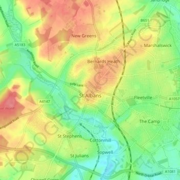
Name: St Albans topographic map, elevation, terrain.
Location: St Albans, Hertfordshire, England, United Kingdom (51.72913 -0.37529 51.78007 -0.29102)
Average elevation: 103 m
Minimum elevation: 69 m
Maximum elevation: 141 m
The borough consisted of the ancient parish of St Albans (also known as the Abbey parish) and parts of the parishes of St Michael and St Peter. The borough was reformed by the Municipal Corporations Act 1835 to become a municipal borough, and the boundary was adjusted to additionally include part of the parish of St Stephen. On 28 August 1877 the borough gained city status, following the elevation of St Albans Abbey to become a cathedral. The boundary was also adjusted in 1877 to include part of the parish of Sandridge.
Other topographic maps
Click on a map to view its topography, its elevation and its terrain.
Newnham
United Kingdom > England > Hertfordshire > North Hertfordshire
Newnham, North Hertfordshire, Hertfordshire, England, United Kingdom
Average elevation: 69 m
Sandridge
United Kingdom > England > Hertfordshire > St Albans
Sandridge, St Albans, Hertfordshire, England, United Kingdom
Average elevation: 105 m
Borehamwood
United Kingdom > England > Hertfordshire > Hertsmere
Borehamwood, Hertsmere, Hertfordshire, England, WD6 5HL, United Kingdom
Average elevation: 104 m
Sandon
United Kingdom > England > Hertfordshire > North Hertfordshire
Sandon, North Hertfordshire, Hertfordshire, England, United Kingdom
Average elevation: 130 m
Frogmore
United Kingdom > England > Hertfordshire > St Albans
Frogmore, St Albans, Hertfordshire, England, AL2 2LS, United Kingdom
Average elevation: 80 m
Harpenden
United Kingdom > England > Hertfordshire > St Albans > Harpenden
Harpenden, St Albans, Hertfordshire, England, United Kingdom
Average elevation: 119 m
Dacorum
United Kingdom > England > Hertfordshire > Dacorum
Dacorum, Hertfordshire, East of England, England, United Kingdom
Average elevation: 142 m
Kings Langley
United Kingdom > England > Hertfordshire > Dacorum
Kings Langley, Dacorum, Hertfordshire, England, United Kingdom
Average elevation: 111 m
Garston
United Kingdom > England > Hertfordshire > Watford > Garston
Garston, Watford, Hertfordshire, East of England, England, WD25 9JT, United Kingdom
Average elevation: 83 m
Potters Bar
United Kingdom > England > Hertfordshire > Hertsmere
Potters Bar, Hertsmere, Hertfordshire, England, EN6 1QG, United Kingdom
Average elevation: 98 m
Bishop's Stortford
United Kingdom > England > Hertfordshire > East Hertfordshire
Bishop's Stortford, East Hertfordshire, Hertfordshire, England, United Kingdom
Average elevation: 83 m
St Albans
United Kingdom > England > Hertfordshire > St Albans
St Albans, Hertfordshire, East of England, England, United Kingdom
Average elevation: 107 m
Hoddesdon
United Kingdom > England > Hertfordshire
Hoddesdon, Broxbourne, Hertfordshire, England, EN11 8UD, United Kingdom
Average elevation: 54 m
Gilston
United Kingdom > England > Hertfordshire > East Hertfordshire > Gilston
Gilston, East Hertfordshire, Hertfordshire, England, United Kingdom
Average elevation: 59 m
Wakeley
United Kingdom > England > Hertfordshire > East Hertfordshire > Buntingford > Westmill > Wakeley
Wakeley, Westmill, Buntingford, East Hertfordshire, Hertfordshire, East of England, England, SG9 9NH, United Kingdom
Average elevation: 121 m