Geolocate

Elbląg County topographic map

Click on the map to display elevation.

About this map

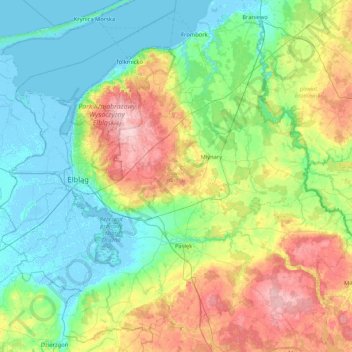
Name: Elbląg County topographic map, elevation, terrain.

Location: Elbląg County, Warmian-Masurian Voivodeship, Poland (53.92629 19.21728 54.39224 20.05820)

Average elevation: 55 m

Minimum elevation: -5 m

Maximum elevation: 197 m

Other topographic maps

Click on a map to view its topography, its elevation and its terrain.

Kętrzyn County

Poland > Warmian-Masurian Voivodeship

Kętrzyn County, Warmian-Masurian Voivodeship, Poland

Average elevation: 93 m

Bartoszyce County

Poland > Warmian-Masurian Voivodeship

Bartoszyce County, Warmian-Masurian Voivodeship, Poland

Average elevation: 98 m

Parys

Poland > Warmian-Masurian Voivodeship > Kętrzyn County

Parys, gmina Korsze, Kętrzyn County, Warmian-Masurian Voivodeship, Poland

Average elevation: 52 m

Kętrzyn

Poland > Warmian-Masurian Voivodeship > Kętrzyn County

Kętrzyn, Kętrzyn County, Warmian-Masurian Voivodeship, Poland

Average elevation: 101 m

Mrągowo County

Poland > Warmian-Masurian Voivodeship

Mrągowo County, Warmian-Masurian Voivodeship, Poland

Average elevation: 141 m

Mrągowo

Poland > Warmian-Masurian Voivodeship

Mrągowo, powiat mrągowski, Warmian-Masurian Voivodeship, 11-700, Poland

Average elevation: 150 m

Olsztynek

Poland > Warmian-Masurian Voivodeship

Olsztynek, gmina Olsztynek, powiat olsztyński, Warmian-Masurian Voivodeship, 11-015, Poland

Average elevation: 174 m

Reszel

Poland > Warmian-Masurian Voivodeship

Reszel, gmina Reszel, powiat kętrzyński, Warmian-Masurian Voivodeship, Poland

Average elevation: 109 m

Bartoszyce

Poland > Warmian-Masurian Voivodeship

Bartoszyce, powiat bartoszycki, Warmian-Masurian Voivodeship, 11-200, Poland

Average elevation: 56 m