
Make a donation
Gear up for your next adventure:
As an Amazon Associate, this site earns from qualifying purchases at no extra cost to you.
Zurich topographic map
Click on the map to display elevation.
Make a donation
Gear up for your next adventure:
As an Amazon Associate, this site earns from qualifying purchases at no extra cost to you.
Zurich
On its west side, the Limmat valley is flanked by the wooded heights of the Albis chain, which runs along the western border. The Uetliberg is, with 869 m (2,851 ft) above sea level, the highest elevation of the surrounding area. Its summit can be reached easily by the Uetlibergbahn. From the platform of the observation tower on the summit, an impressive panorama of the city, the lake, and the Alps can be seen.
Make a donation
Gear up for your next adventure:
As an Amazon Associate, this site earns from qualifying purchases at no extra cost to you.
About this map
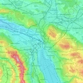
Name: Zurich topographic map, elevation, terrain.
Location: Zurich, District Zurich, Zurich, Switzerland (47.32022 8.44801 47.43467 8.62544)
Average elevation: 499 m
Minimum elevation: 391 m
Maximum elevation: 857 m
Make a donation
Gear up for your next adventure:
As an Amazon Associate, this site earns from qualifying purchases at no extra cost to you.
Other topographic maps
Click on a map to view its topography, its elevation and its terrain.
Ötlisberg
Switzerland > Zurich > District Zurich > Zurich
Öschbrig (also known as Oetlisberg) with an elevation of 696 metres (2,283 ft), is a wooded mountain in Switzerland overlooking to the east Zürichsee (Lake Zürich).
Average elevation: 626 m