
Make a donation
Gear up for your next adventure:
As an Amazon Associate, this site earns from qualifying purchases at no extra cost to you.
Gunungkidul Regency topographic map
Click on the map to display elevation.
Make a donation
Gear up for your next adventure:
As an Amazon Associate, this site earns from qualifying purchases at no extra cost to you.
About this map
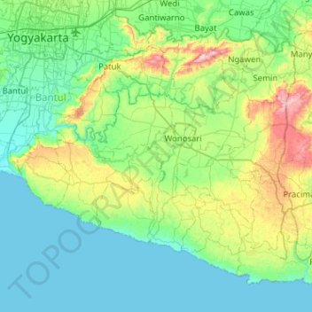
Name: Gunungkidul Regency topographic map, elevation, terrain.
Average elevation: 158 m
Minimum elevation: 0 m
Maximum elevation: 791 m
Make a donation
Gear up for your next adventure:
As an Amazon Associate, this site earns from qualifying purchases at no extra cost to you.
Other topographic maps
Click on a map to view its topography, its elevation and its terrain.
Make a donation
Gear up for your next adventure:
As an Amazon Associate, this site earns from qualifying purchases at no extra cost to you.
Make a donation
Gear up for your next adventure:
As an Amazon Associate, this site earns from qualifying purchases at no extra cost to you.
Kopeng Kepuhharjo
Indonesia > Special Region of Yogyakarta > Sleman Regency > Kepuhharjo
Average elevation: 755 m
Sendang Tirto
Indonesia > Special Region of Yogyakarta > Sleman Regency > Sendangtirto
Average elevation: 92 m
Sepanjang Beach
Indonesia > Special Region of Yogyakarta > Gunungkidul Regency > Kemadang
Average elevation: 15 m
Make a donation
Gear up for your next adventure:
As an Amazon Associate, this site earns from qualifying purchases at no extra cost to you.
Laut Bekah
Indonesia > Special Region of Yogyakarta > Gunung Kidul Regency > Girikarto
Average elevation: 38 m
Candi Binangun
Indonesia > Special Region of Yogyakarta > Sleman Regency > Candibinangun
Average elevation: 453 m
Siraman
Indonesia > Special Region of Yogyakarta > Gunung Kidul Regency > Siraman
Average elevation: 177 m
Make a donation
Gear up for your next adventure:
As an Amazon Associate, this site earns from qualifying purchases at no extra cost to you.
Gunung Merapi
Indonesia > Special Region of Yogyakarta > Sleman Regency > Hargobinangun
Average elevation: 2,259 m
Depok Beach
Indonesia > Special Region of Yogyakarta > Bantul Regency > Parangtritis
Average elevation: 3 m
Janti
Indonesia > Special Region of Yogyakarta > Sleman Regency > Catur tunggal
Average elevation: 124 m
Make a donation
Gear up for your next adventure:
As an Amazon Associate, this site earns from qualifying purchases at no extra cost to you.
Cepetsari Glagahharjo
Indonesia > Special Region of Yogyakarta > Sleman Regency > Glagah Harjo
Average elevation: 500 m
Karangmalang
Indonesia > Special Region of Yogyakarta > Sleman Regency > Catur tunggal
Average elevation: 139 m
Ijo Temple
Indonesia > Special Region of Yogyakarta > Sleman Regency > Sambirejo
The temple compound is located in Groyokan hamlet, Sambirejo village, Kecamatan Prambanan, Sleman Regency, Yogyakarta. The temple's name derived from its location, the Gumuk Ijo hill. The temple compound stood on western slope of the hill, in a quiet region east of Yogyakarta, around 4 kilometers southeast…
Average elevation: 233 m
Kayen
Indonesia > Special Region of Yogyakarta > Sleman Regency > Condongcatur
Average elevation: 182 m
Make a donation
Gear up for your next adventure:
As an Amazon Associate, this site earns from qualifying purchases at no extra cost to you.
Make a donation
Gear up for your next adventure:
As an Amazon Associate, this site earns from qualifying purchases at no extra cost to you.
Gerojogan Lepo
Indonesia > Special Region of Yogyakarta > Bantul Regency > Dlingo
Average elevation: 133 m
Sawungan
Indonesia > Special Region of Yogyakarta > Sleman Regency > Hargobinangun
Average elevation: 552 m
Wisdom park
Indonesia > Special Region of Yogyakarta > Sleman Regency > Catur tunggal
Average elevation: 136 m
Make a donation
Gear up for your next adventure:
As an Amazon Associate, this site earns from qualifying purchases at no extra cost to you.
Ngipiksari
Indonesia > Special Region of Yogyakarta > Sleman Regency > Hargobinangun > Kaliurang
Average elevation: 794 m
Condong Catur
Indonesia > Special Region of Yogyakarta > Sleman Regency > Condongcatur > Condong Catur
Average elevation: 163 m
Embung Tambakboyo
Indonesia > Special Region of Yogyakarta > Sleman Regency > Condongcatur > Condongcatur
Average elevation: 164 m
Kaliurang
Indonesia > Special Region of Yogyakarta > Sleman Regency > Hargobinangun
Average elevation: 858 m
Make a donation
Gear up for your next adventure:
As an Amazon Associate, this site earns from qualifying purchases at no extra cost to you.