Geolocate

Cowes topographic map

Click on the map to display elevation.

About this map

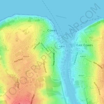
Name: Cowes topographic map, elevation, terrain.

Location: Cowes, Isle of Wight, England, United Kingdom (50.74769 -1.32105 50.76756 -1.29143)

Average elevation: 25 m

Minimum elevation: 0 m

Maximum elevation: 65 m

Other topographic maps

Click on a map to view its topography, its elevation and its terrain.

Carisbrooke

United Kingdom > England > Isle of Wight

Average elevation: 42 m

Chessell

United Kingdom > England > Isle of Wight

Average elevation: 69 m

Gear up for your next adventure:

🗺️Topographic Maps - Detailed maps for hiking and navigation
🐍Australian Snake Bite Kits - Specific pressure immobilization bandages for Australian venomous snakes
🛌Sleeping Bags - Sleeping bags for outdoor camping
📷Backpack Camera Clips - Quick access to your camera while keeping your hands free for climbing
🚗Car Camping Gear - Equipment for vehicle camping

As an Amazon Associate, this site earns from qualifying purchases at no extra cost to you.