
Make a donation
Gear up for your next adventure:
As an Amazon Associate, this site earns from qualifying purchases at no extra cost to you.
Franklin topographic map
Click on the map to display elevation.
Make a donation
Gear up for your next adventure:
As an Amazon Associate, this site earns from qualifying purchases at no extra cost to you.
Franklin
The height of the falls is given as 200 ft (61 m) in Kevin Adams' book, North Carolina Waterfalls and 250 ft (77.1 m) by NCWaterfalls.com. However, Google Earth gives a height (based on the elevation of the water at the top of the falls and the elevation of the plunge pool at the bottom of the falls) of 137 ft (42 m). The falls may be glimpsed by people driving along Highway 64, but it is difficult to see more fully from the road. The falls are located beside of a series of blind curves on with sheer rock cliffs above and below the road. A small pull-off is located near the falls, but walking on the road puts visitors in danger of being hit by a passing vehicle.
Make a donation
Gear up for your next adventure:
As an Amazon Associate, this site earns from qualifying purchases at no extra cost to you.
About this map
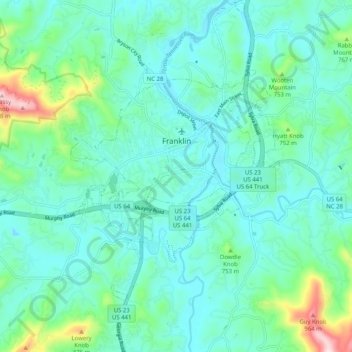
Name: Franklin topographic map, elevation, terrain.
Location: Franklin, Macon County, North Carolina, 28734, United States (35.13238 -83.43950 35.21556 -83.35178)
Average elevation: 675 m
Minimum elevation: 598 m
Maximum elevation: 1,013 m
Make a donation
Gear up for your next adventure:
As an Amazon Associate, this site earns from qualifying purchases at no extra cost to you.
Other topographic maps
Click on a map to view its topography, its elevation and its terrain.