
New Washoe City topographic map
Interactive map
Click on the map to display elevation.
About this map
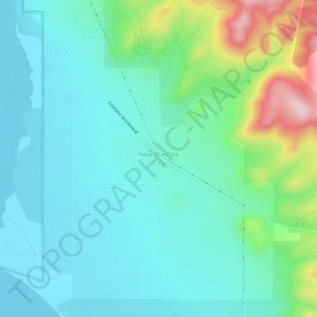
Name: New Washoe City topographic map, elevation, terrain.
Location: New Washoe City, Washoe County, Nevada, United States (39.27137 -119.79061 39.31137 -119.75061)
Average elevation: 1,589 m
Minimum elevation: 1,529 m
Maximum elevation: 1,793 m
Other topographic maps
Click on a map to view its topography, its elevation and its terrain.
Sparks
United States > Nevada > Washoe County > Sparks > Sparks
Sparks, Washoe County, Nevada, 89431-5025, United States
Average elevation: 1,636 m
Sparks
United States > Nevada > Washoe County
Sparks, Washoe County, Nevada, United States
Average elevation: 1,438 m
Reno
United States > Nevada > Washoe County
Reno, Washoe County, Nevada, United States
Average elevation: 1,650 m