
Gemeinde St. Pölten topographic map
Interactive map
Click on the map to display elevation.
About this map
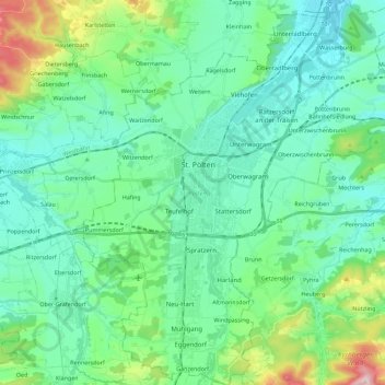
Name: Gemeinde St. Pölten topographic map, elevation, terrain.
Location: Gemeinde St. Pölten, Lower Austria, Austria (48.11848 15.55590 48.26830 15.73918)
Average elevation: 309 m
Minimum elevation: 227 m
Maximum elevation: 625 m
Other topographic maps
Click on a map to view its topography, its elevation and its terrain.
Kleinwolfstein
Austria > Lower Austria > Bezirk Amstetten > Neustadtl an der Donau
Average elevation: 364 m
Schenkenbrunn
Austria > Lower Austria > Bezirk Krems > Bergern im Dunkelsteinerwald
Average elevation: 511 m
Poysdorf
Austria > Lower Austria > Bezirk Mistelbach > Gemeinde Poysdorf > Poysdorf
Average elevation: 246 m