
Make a donation
Gear up for your next adventure:
As an Amazon Associate, this site earns from qualifying purchases at no extra cost to you.
Pitalito topographic map
Click on the map to display elevation.
Make a donation
Gear up for your next adventure:
As an Amazon Associate, this site earns from qualifying purchases at no extra cost to you.
Pitalito
The valley itself lies at about 1,300 meters above sea level. All the surrounding mountains grow coffee with the average farm having about 6 hectares and about 5,000 trees per hectare. The soil is volcanic, providing plenty of organic nutrients for the high altitude coffee.
Make a donation
Gear up for your next adventure:
As an Amazon Associate, this site earns from qualifying purchases at no extra cost to you.
About this map
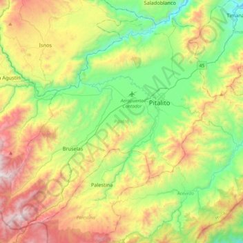
Name: Pitalito topographic map, elevation, terrain.
Location: Pitalito, Sur, Huila, 417030, Colombia (1.65724 -76.32189 1.97668 -75.96183)
Average elevation: 1,635 m
Minimum elevation: 969 m
Maximum elevation: 2,762 m
Make a donation
Gear up for your next adventure:
As an Amazon Associate, this site earns from qualifying purchases at no extra cost to you.
Other topographic maps
Click on a map to view its topography, its elevation and its terrain.
Make a donation
Gear up for your next adventure:
As an Amazon Associate, this site earns from qualifying purchases at no extra cost to you.
Altamira
Altamira is a small pueblo in the department Huila, with a population around 2,416. Its geographical coordinates are 2° 3' 46" North, 75° 47' 14" West. It is about an 8-hour bus trip south of Bogota. The largest city in Huila and its capital is Neiva, which is 89 miles north, with a population of about…
Average elevation: 1,032 m
Make a donation
Gear up for your next adventure:
As an Amazon Associate, this site earns from qualifying purchases at no extra cost to you.