
Genoa topographic map
Click on the map to display elevation.
Genoa
The city of Genoa covers an area of 243 square kilometres (94 sq mi) between the Ligurian Sea and the Apennine Mountains. The city stretches along the coast for about 30 kilometres (19 mi) from the neighbourhood of Voltri to Nervi, and for 10 kilometres (6.2 mi) from the coast to the north along the valleys Polcevera and Bisagno. The territory of Genoa is popularly divided into 5 main zones: the centre, the west, the east, the Polcevera and the Bisagno Valley. Although much of the city centre is located at a low elevation, the territory surrounding it is mountainous with undeveloped land usually being in steep terrain.
About this map
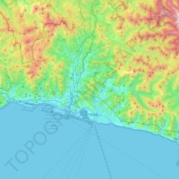
Name: Genoa topographic map, elevation, terrain.
Location: Genoa, Liguria, Italy (44.37847 8.66574 44.51984 9.09558)
Average elevation: 333 m
Minimum elevation: -4 m
Maximum elevation: 1,525 m