
Make a donation
Gear up for your next adventure:
As an Amazon Associate, this site earns from qualifying purchases at no extra cost to you.
Phnom Penh topographic map
Click on the map to display elevation.
Make a donation
Gear up for your next adventure:
As an Amazon Associate, this site earns from qualifying purchases at no extra cost to you.
About this map
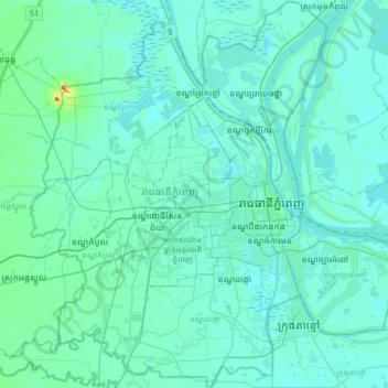
Name: Phnom Penh topographic map, elevation, terrain.
Location: Phnom Penh, Cambodia (11.42009 104.72040 11.73495 105.04403)
Average elevation: 13 m
Minimum elevation: 1 m
Maximum elevation: 134 m
Make a donation
Gear up for your next adventure:
As an Amazon Associate, this site earns from qualifying purchases at no extra cost to you.
Other topographic maps
Click on a map to view its topography, its elevation and its terrain.
Make a donation
Gear up for your next adventure:
As an Amazon Associate, this site earns from qualifying purchases at no extra cost to you.
Sangkat Phsar Thmey Ti Muoy
Cambodia > Phnom Penh > Khan Daun Penh > Sangkat Phsar Thmey Ti Muoy
Average elevation: 13 m