
Rzeszów topographic map
Interactive map
Click on the map to display elevation.
About this map
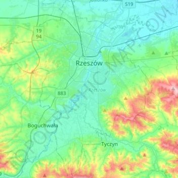
Name: Rzeszów topographic map, elevation, terrain.
Location: Rzeszów, Subcarpathian Voivodeship, Poland (49.93258 21.85868 50.09419 22.09415)
Average elevation: 238 m
Minimum elevation: 190 m
Maximum elevation: 399 m
Other topographic maps
Click on a map to view its topography, its elevation and its terrain.
Sękowiec
Poland > Subcarpathian Voivodeship > Bieszczady County > Zatwarnica
Sękowiec, Zatwarnica, gmina Lutowiska, Bieszczady County, Subcarpathian Voivodeship, 38-713, Poland
Average elevation: 587 m
Bieszczady County
Poland > Subcarpathian Voivodeship
Bieszczady County, Subcarpathian Voivodeship, Poland
Average elevation: 554 m
Siedliska-Bogusz
Poland > Subcarpathian Voivodeship > Siedliska-Bogusz
Siedliska-Bogusz, gmina Brzostek, Dębica County, Subcarpathian Voivodeship, 39-231, Poland
Average elevation: 298 m