Geolocate

Thruxton topographic map

Click on the map to display elevation.

About this map
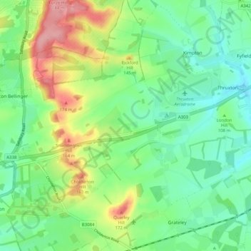
Name: Thruxton topographic map, elevation, terrain.

Location: Thruxton, Test Valley, Hampshire, England, United Kingdom (51.18481 -1.66946 51.21679 -1.56947)

Average elevation: 111 m

Minimum elevation: 71 m

Maximum elevation: 189 m

Other topographic maps

Click on a map to view its topography, its elevation and its terrain.
Gosport

United Kingdom > England > Hampshire > Test Valley > Ampfield

Average elevation: 46 m

Gear up for your next adventure:

🔋Solar Power Banks - Charge your phone and GPS using the sun while deep in the bush
🥾Hiking Boots - Durable hiking boots for trails and rough terrain
📡Portable Emergency Radios - Stay informed about weather warnings and bushfire alerts
🥾Hiking Shoes - Lightweight hiking shoes for day hikes
🎨Portable Watercolor Kits - Paint the landscapes and topographic views you discover

As an Amazon Associate, this site earns from qualifying purchases at no extra cost to you.