Geolocate

Naga topographic map

Click on the map to display elevation.

About this map

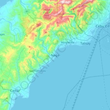
Name: Naga topographic map, elevation, terrain.

Location: Naga, Cebu, Central Visayas, 6037, Philippines (10.04847 123.59910 10.36847 123.91910)

Average elevation: 102 m

Minimum elevation: -1 m

Maximum elevation: 751 m

Gear up for your next adventure:

🎒3L Hydration Reservoirs - Hands-free drinking to stay hydrated on steep contour climbs
🦟Insect Repellent - Protection against insects
Survival Blankets - Emergency thermal blankets
🩹First Aid Kits - Emergency kits for hiking
🧭Compass - Navigation compasses for outdoor exploration

As an Amazon Associate, this site earns from qualifying purchases at no extra cost to you.