
Harrison County topographic map
Interactive map
Click on the map to display elevation.
About this map
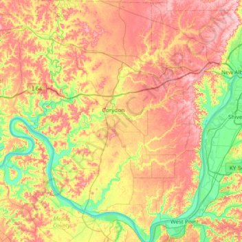
Name: Harrison County topographic map, elevation, terrain.
Location: Harrison County, Indiana, USA (37.95869 -86.33109 38.42240 -85.89986)
Average elevation: 205 m
Minimum elevation: 115 m
Maximum elevation: 308 m
Other topographic maps
Click on a map to view its topography, its elevation and its terrain.
Brown’s Ridge
USA > Indiana > Beverly Shores
Brown’s Ridge, Beverly Shores, Porter County, Indiana, 46301, USA
Average elevation: 183 m
New Frankfort
USA > Indiana > New Frankfort
New Frankfort, Scott County, Indiana, 74710, USA
Average elevation: 190 m
Huntington
USA > Indiana > Huntington
Huntington, Huntington County, Indiana, 46750, USA
Average elevation: 238 m
Mound Haven
USA > Indiana > Mound Haven
Mound Haven, Franklin County, Indiana, 47012, USA
Average elevation: 231 m
Woodville Hills
USA > Indiana > Woodville Hills
Woodville Hills, Monroe County, Indiana, USA
Average elevation: 196 m
Mount Bentley
USA > Indiana > Dune Acres
Mount Bentley, Dune Acres, Porter County, Indiana, USA
Average elevation: 183 m