Geolocate

Arvada topographic map

Click on the map to display elevation.

About this map

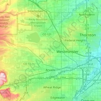
Name: Arvada topographic map, elevation, terrain.

Location: Arvada, Jefferson County, Colorado, United States (39.78438 -105.30192 39.89302 -105.04231)

Average elevation: 1,665 m

Minimum elevation: 1,549 m

Maximum elevation: 1,999 m

Other topographic maps

Click on a map to view its topography, its elevation and its terrain.

Evergreen

United States > Colorado > Jefferson County

Evergreen sits at an elevation of 7,220 feet (2,200 m) in the Rocky Mountains, 19 miles west of Denver, Colorado.

Average elevation: 2,301 m

Lakewood

United States > Colorado > Jefferson County > Lakewood

Lakewood is located at 39°42′17″N 105°04′53″W / 39.70472°N 105.08139°W / 39.70472; -105.08139 at an elevation of 5,518 feet (1,682 m). Located at the junction of U.S. Route 6 and Colorado State Highway 121 in central Colorado, the city lies immediately west of Denver and 62 miles (100 km)…

Average elevation: 1,717 m

Gear up for your next adventure:

📷Backpack Camera Clips - Quick access to your camera while keeping your hands free for climbing
🧴SPF 50+ Bulk Sunscreen - Maximum protection for long-term outdoor exposure
🧥Insulated Down Jackets - High warmth-to-weight ratio for cold nights in the high country
🧭Military Style Lensatic Compass - Durable sighting compasses for advanced land navigation and surveying
🧥Down Jackets - Insulated jackets for cold weather

As an Amazon Associate, this site earns from qualifying purchases at no extra cost to you.