
Ceduna topographic map
Interactive map
Click on the map to display elevation.
About this map
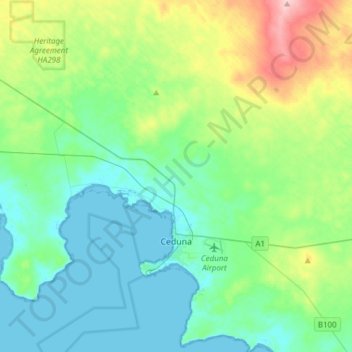
Name: Ceduna topographic map, elevation, terrain.
Average elevation: 35 m
Minimum elevation: 0 m
Maximum elevation: 149 m
Other topographic maps
Click on a map to view its topography, its elevation and its terrain.
Smoky Bay
Australia > South Australia > The District Council of Ceduna
Smoky Bay, The District Council of Ceduna, South Australia, 5680, Australia
Average elevation: 9 m
Thevenard
Australia > South Australia > The District Council of Ceduna > Thevenard
Thevenard, The District Council of Ceduna, South Australia, 5690, Australia
Average elevation: 2 m