
Make a donation
Gear up for your next adventure:
As an Amazon Associate, this site earns from qualifying purchases at no extra cost to you.
Fremantle topographic map
Click on the map to display elevation.
Make a donation
Gear up for your next adventure:
As an Amazon Associate, this site earns from qualifying purchases at no extra cost to you.
About this map
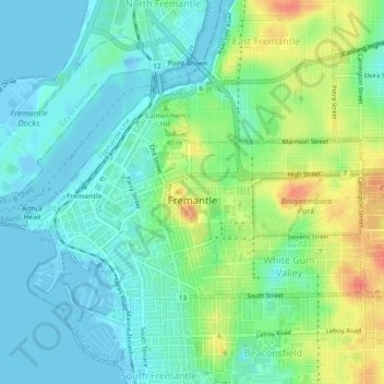
Name: Fremantle topographic map, elevation, terrain.
Location: Fremantle, City of Fremantle, Western Australia, Australia (-32.06394 115.73220 -32.04118 115.77973)
Average elevation: 17 m
Minimum elevation: -10 m
Maximum elevation: 55 m
City of Fremantle trails, hiking, mountain biking, running and outdoor activities
Make a donation
Gear up for your next adventure:
As an Amazon Associate, this site earns from qualifying purchases at no extra cost to you.
Other topographic maps
Click on a map to view its topography, its elevation and its terrain.
Fremantle Inner Harbour
Australia > Western Australia > City of Fremantle > Fremantle
Average elevation: 7 m
Make a donation
Gear up for your next adventure:
As an Amazon Associate, this site earns from qualifying purchases at no extra cost to you.