Geolocate

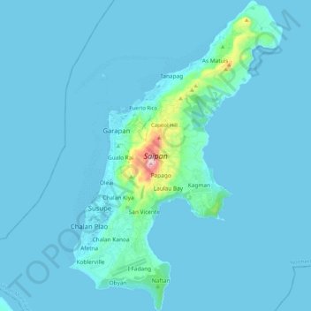
Saipan topographic map

Click on the map to display elevation.

Saipan

The highest elevation on Saipan is a limestone-covered mountain called Mount Tapochau at 1,560 ft (480 m). Unlike many of the mountains in the Mariana Islands, it is not an extinct volcano but is a limestone formation.

Wikipedia (CC-BY-SA 3.0)

About this map

Name: Saipan topographic map, elevation, terrain.

Location: Saipan, Tanapag, Garapan, Saipan Municipality, Northern Mariana Islands, 96950, United States (15.09193 145.68957 15.29001 145.83051)

Average elevation: 22 m

Minimum elevation: 0 m

Maximum elevation: 462 m

Gear up for your next adventure:

📍Handheld GPS - GPS devices for hiking and navigation
🔋Solar Power Banks - Solar chargers for outdoors
🩹Wilderness First Aid Kits - Comprehensive medical kits tailored for hiking and remote exploration
📸Action Cameras - Record your journey across interesting topographic features in 4K
🧼Biodegradable Outdoor Soap - Clean gear and yourself without harming the local ecosystem

As an Amazon Associate, this site earns from qualifying purchases at no extra cost to you.