
Town of Bridgewater topographic map
Interactive map
Click on the map to display elevation.
About this map
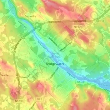
Name: Town of Bridgewater topographic map, elevation, terrain.
Location: Town of Bridgewater, Lunenburg County, Nova Scotia, Canada (44.35760 -64.56427 44.40550 -64.48875)
Average elevation: 56 m
Minimum elevation: -2 m
Maximum elevation: 118 m
Bridgewater spans the width of the LaHave River Valley and is dominated by hills that lead down to the river. Elevations range from 5 m above sea level at the river, to nearly 110 m at the southwestern border. Like much of Southern Nova Scotia, the surrounding area is characterized by rolling drumlins formed during the last glacial period, some of which reach 150 m above sea level. The LaHave River is traversed by two bridges in the centre of the town, as well as a 103 highway overpass and foot bridge towards the northern limits.
Other topographic maps
Click on a map to view its topography, its elevation and its terrain.
Robinsons Corner
Canada > Nova Scotia > Lunenburg County
Robinsons Corner, Chester District Municipality, Lunenburg County, Nova Scotia, B0J 1J0, Canada
Average elevation: 59 m
Oak Island
Canada > Nova Scotia > Lunenburg County > Western Shore
Oak Island, Western Shore, Chester District Municipality, Lunenburg County, Nova Scotia, B0J 3M0, Canada
Average elevation: 74 m