
Make a donation
Gear up for your next adventure:
As an Amazon Associate, this site earns from qualifying purchases at no extra cost to you.
Wörderfeld topographic map
Click on the map to display elevation.
Make a donation
Gear up for your next adventure:
As an Amazon Associate, this site earns from qualifying purchases at no extra cost to you.
Wörderfeld
Wörderfeld liegt auf einer Höhe von 240 m ü. NHN und rund zehn Kilometer südöstlich der Kernstadt Lügde. Die Flächengröße beträgt 6,146 km². Der Ortsteil liegt im äußersten Südosten Lippes. Im Süden erhebt sich der Kiels Berg, im Südwesten liegt der Kloster- und der Kalaxberg und im Osten und Norden steigt das Land zur rund 300 ;Meter hohen Ottensteiner Hochebene an.
Make a donation
Gear up for your next adventure:
As an Amazon Associate, this site earns from qualifying purchases at no extra cost to you.
About this map
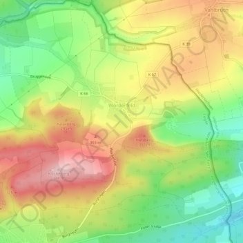
Name: Wörderfeld topographic map, elevation, terrain.
Location: Wörderfeld, Lügde, Kreis Lippe, Nordrhein-Westfalen, Deutschland (51.88981 9.29926 51.92300 9.34602)
Average elevation: 240 m
Minimum elevation: 140 m
Maximum elevation: 341 m
Make a donation
Gear up for your next adventure:
As an Amazon Associate, this site earns from qualifying purchases at no extra cost to you.
Other topographic maps
Click on a map to view its topography, its elevation and its terrain.
Vogelhorst
Deutschland > Nordrhein-Westfalen > Kreis Lippe > Lemgo > Voßheide
Average elevation: 143 m
Make a donation
Gear up for your next adventure:
As an Amazon Associate, this site earns from qualifying purchases at no extra cost to you.