
Area D (Oyster Bay/Buttle Lake) topographic map
Interactive map
Click on the map to display elevation.
About this map
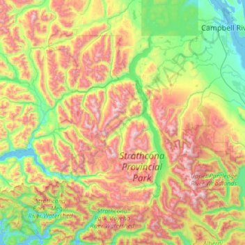
Name: Area D (Oyster Bay/Buttle Lake) topographic map, elevation, terrain.
Average elevation: 723 m
Minimum elevation: -1 m
Maximum elevation: 2,120 m
Other topographic maps
Click on a map to view its topography, its elevation and its terrain.
Garden Point
Canada > British Columbia > Strathcona Regional District
Garden Point, Strathcona Regional District, British Columbia, Canada
Average elevation: 16 m
Tennent Creek
Canada > British Columbia > Strathcona Regional District > Area D (Oyster Bay/Buttle Lake)
Tennent Creek, Area D (Oyster Bay/Buttle Lake), Strathcona Regional District, British Columbia, Canada
Average elevation: 1,005 m