
Apex topographic map
Click on the map to display elevation.
About this map
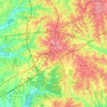
Name: Apex topographic map, elevation, terrain.
Location: Apex, Wake County, North Carolina, 27502, United States (35.66483 -78.96900 35.77868 -78.80258)
Average elevation: 115 m
Minimum elevation: 70 m
Maximum elevation: 158 m
Other topographic maps
Click on a map to view its topography, its elevation and its terrain.
Lake Johnson
United States > North Carolina > Wake County > Raleigh > Orchards
Average elevation: 121 m
Prestonwood Soccer Complex
United States > North Carolina > Wake County > Cary
Average elevation: 111 m
Lake Raleigh
United States > North Carolina > Wake County > Raleigh > Isle Forest
Average elevation: 104 m