Geolocate

Kilmarnock topographic map

Click on the map to display elevation.

About this map

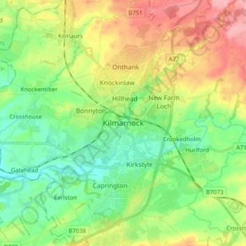
Name: Kilmarnock topographic map, elevation, terrain.

Location: Kilmarnock, East Ayrshire, Scotland, KA1 1HZ, United Kingdom (55.57006 -4.53647 55.65006 -4.45647)

Average elevation: 56 m

Minimum elevation: 12 m

Maximum elevation: 128 m

Other topographic maps

Click on a map to view its topography, its elevation and its terrain.

Braid Wood

United Kingdom > Scotland > East Ayrshire

Average elevation: 114 m

Glenbuck Loch

United Kingdom > Scotland > East Ayrshire

Average elevation: 327 m

Loch Doon

United Kingdom > Scotland > East Ayrshire

Average elevation: 291 m

River Doon

United Kingdom > Scotland > East Ayrshire > Dalrymple

Average elevation: 168 m

River Ayr

United Kingdom > Scotland > East Ayrshire

Average elevation: 210 m

Gear up for your next adventure:

🧥Packable Rain Jackets - Breathable waterproof layers for unpredictable mountain weather
🧣Merino Neck Gaiters - Versatile headwear for warmth, sun protection, or dust filtering
🌬️Windbreaker Jackets - Wind protection jackets
🔦Headlamps - Hands-free lighting for hiking
🧼Biodegradable Outdoor Soap - Clean gear and yourself without harming the local ecosystem

As an Amazon Associate, this site earns from qualifying purchases at no extra cost to you.