
Make a donation
Gear up for your next adventure:
As an Amazon Associate, this site earns from qualifying purchases at no extra cost to you.
Jersey City topographic map
Click on the map to display elevation.
Make a donation
Gear up for your next adventure:
As an Amazon Associate, this site earns from qualifying purchases at no extra cost to you.
Jersey City
Jersey City (and most of Hudson County) is located on the peninsula known as Bergen Neck, with a waterfront on the east at the Hudson River and New York Bay and on the west at the Hackensack River and Newark Bay. Its north–south axis corresponds with the ridge of Bergen Hill, the emergence of the Hudson Palisades. The city is the site of some of the earliest European settlements in North America, which grew into each other rather than expanding from a central point. This growth and the topography greatly influenced the development of the sections of the city and its various neighborhoods.
Make a donation
Gear up for your next adventure:
As an Amazon Associate, this site earns from qualifying purchases at no extra cost to you.
About this map
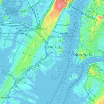
Name: Jersey City topographic map, elevation, terrain.
Location: Jersey City, Hudson County, New Jersey, United States (40.66162 -74.11669 40.76894 -74.02064)
Average elevation: 9 m
Minimum elevation: -8 m
Maximum elevation: 80 m
Make a donation
Gear up for your next adventure:
As an Amazon Associate, this site earns from qualifying purchases at no extra cost to you.
Other topographic maps
Click on a map to view its topography, its elevation and its terrain.