Geolocate

Mount Keith topographic map

Click on the map to display elevation.

About this map

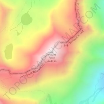
Name: Mount Keith topographic map, elevation, terrain.

Location: Mount Keith, Tulare County, California, United States (36.70016 -118.34348 36.70026 -118.34338)

Average elevation: 3,702 m

Minimum elevation: 3,062 m

Maximum elevation: 4,235 m

Gear up for your next adventure:

🥾Hiking Gaiters - Leg protection for trails
🦟Insect Repellent - Protection against insects
🩹First Aid Kits - Emergency kits for hiking
🧺Waterproof Dry Sacks - Organize your pack and keep electronics safe from rain and river crossings
🎒40L Day Hiking Backpacks - Comfortable packs with hydration support for long days exploring topographic peaks

As an Amazon Associate, this site earns from qualifying purchases at no extra cost to you.