Geolocate

Tretes topographic map

Click on the map to display elevation.

About this map

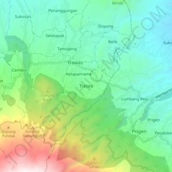
Name: Tretes topographic map, elevation, terrain.

Location: Tretes, Mojokerto, East Java, 61375, Indonesia (-7.71568 112.56774 -7.63568 112.64774)

Average elevation: 874 m

Minimum elevation: 331 m

Maximum elevation: 2,310 m

Gear up for your next adventure:

🔥Camping Stoves - Portable stoves for outdoor cooking
🧥Down Jackets - Insulated jackets for cold weather
📟Satellite Messengers - Two-way satellite communication to stay in touch beyond the cellular grid
🧥Thermal Emergency Blankets - Compact Mylar blankets to prevent hypothermia if stranded overnight
💧Personal Water Filters - Drink safely from streams and lakes identified on your map

As an Amazon Associate, this site earns from qualifying purchases at no extra cost to you.