
Dunloy topographic map
Click on the map to display elevation.
About this map
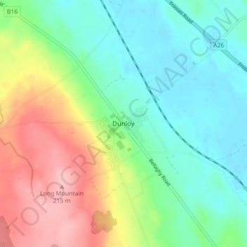
Name: Dunloy topographic map, elevation, terrain.
Average elevation: 128 m
Minimum elevation: 82 m
Maximum elevation: 213 m
Other topographic maps
Click on a map to view its topography, its elevation and its terrain.
Loughgiel Millennium Centre
United Kingdom > Northern Ireland > County Antrim > Loughguile
Average elevation: 155 m
Causeway Coast AONB
United Kingdom > Northern Ireland > County Antrim > Ballintoy
Average elevation: 34 m
Shane's Castle Park
United Kingdom > Northern Ireland > County Antrim > Randalstown
Average elevation: 30 m
Lagan Navigation (Abandoned)
United Kingdom > Northern Ireland > County Antrim > Belfast
Average elevation: 29 m
Mid and East Antrim District
United Kingdom > Northern Ireland > County Antrim
Average elevation: 111 m
Antrim and Newtownabbey District
United Kingdom > Northern Ireland > County Antrim
Average elevation: 97 m
Kinbane Castle
United Kingdom > Northern Ireland > County Antrim > Ballycastle
Average elevation: 37 m
Mid and East Antrim District
United Kingdom > Northern Ireland > County Antrim
Average elevation: 111 m
Antrim and Newtownabbey District
United Kingdom > Northern Ireland > County Antrim
Average elevation: 97 m
Mid and East Antrim District
United Kingdom > Northern Ireland > County Antrim
Average elevation: 111 m
Antrim and Newtownabbey District
United Kingdom > Northern Ireland > County Antrim
Average elevation: 97 m