Geolocate

Munnar topographic map

Click on the map to display elevation.

About this map

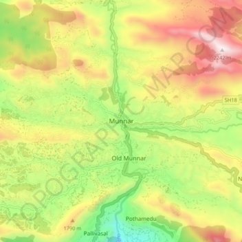
Name: Munnar topographic map, elevation, terrain.

Location: Munnar, Devikulam, Idukki District, Kerala, 685612, India (10.04700 77.02009 10.12700 77.10009)

Average elevation: 1,603 m

Minimum elevation: 1,042 m

Maximum elevation: 2,224 m

Gear up for your next adventure:

🧭Compass - Navigation compasses for outdoor exploration
🧼Biodegradable Outdoor Soap - Clean gear and yourself without harming the local ecosystem
🧥Thermal Emergency Blankets - Compact Mylar blankets to prevent hypothermia if stranded overnight
🔋Rechargeable Batteries - Eco-friendly power for high-drain GPS units and flashlights
GPS Watches - GPS watches for outdoor sports

As an Amazon Associate, this site earns from qualifying purchases at no extra cost to you.