Geolocate

Tabatinga topographic map

Click on the map to display elevation.

About this map
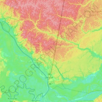
Name: Tabatinga topographic map, elevation, terrain.

Location: Tabatinga, Região Geográfica Imediata de Tabatinga, Região Geográfica Intermediária de Tefé, Amazonas, North Region, 69640-000, Brazil (-4.38111 -69.95007 -3.68016 -69.39900)

Average elevation: 90 m

Minimum elevation: 55 m

Maximum elevation: 145 m

Other topographic maps

Click on a map to view its topography, its elevation and its terrain.

Japura

Brazil > Amazonas > Ipixuna

Average elevation: 157 m

Curua

Brazil > Amazonas > Silves

Average elevation: 22 m

Pauini

Brazil > Amazonas > Pauini > Pauini

Average elevation: 96 m

Gear up for your next adventure:

🛰️Handheld GPS Units - Rugged GPS devices for tracking coordinates and elevation in the Australian bush
🌧️Rain Jackets - Waterproof jackets for hiking
🧼Clip-on Hand Sanitizer - Maintain hygiene when water for washing is scarce
🧊Insulated Stainless Steel Flasks - Keep water cold for 24 hours in the heat or coffee hot in the cold
🧊Insulated Cooler Bags - Keep food fresh for day trips to remote geographic sites

As an Amazon Associate, this site earns from qualifying purchases at no extra cost to you.