Geolocate

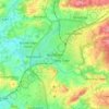
Upper Beeding topographic map

Click on the map to display elevation.

About this map
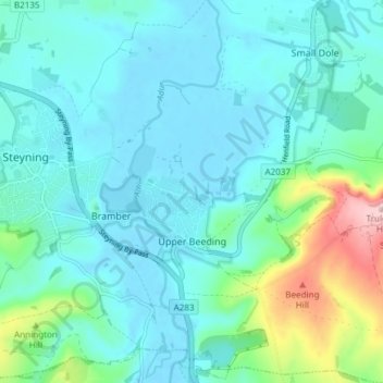
Name: Upper Beeding topographic map, elevation, terrain.

Location: Upper Beeding, Horsham, West Sussex, England, United Kingdom (50.86216 -0.30962 50.90956 -0.23927)

Average elevation: 38 m

Minimum elevation: -4 m

Maximum elevation: 214 m

Other topographic maps

Click on a map to view its topography, its elevation and its terrain.
Cootham

United Kingdom > England > West Sussex > Horsham > Storrington

Average elevation: 51 m

Horsham

United Kingdom > England > West Sussex > Horsham

Average elevation: 62 m

Wiggonholt

United Kingdom > England > West Sussex > Horsham > Wiggonholt

Average elevation: 17 m

Hardham

United Kingdom > England > West Sussex > Horsham > Coldwaltham

Average elevation: 13 m

Wineham

United Kingdom > England > West Sussex > Horsham

Average elevation: 18 m

Barns Green

United Kingdom > England > West Sussex > Horsham

Average elevation: 49 m

Horsham

United Kingdom > England > West Sussex > Horsham

Average elevation: 62 m

Hardham

United Kingdom > England > West Sussex > Horsham > Coldwaltham

Average elevation: 13 m

Horsham

United Kingdom > England > West Sussex > Horsham

Average elevation: 62 m

Gear up for your next adventure:

🧭Compass - Navigation compasses for outdoor exploration
🥾Trail Running Shoes - Shoes for trail running
🔌Fast Charging Adapters - Quickly top up all your gear before heading back into the field
⌛Survival Blankets - Emergency thermal blankets
🎒3L Hydration Reservoirs - Hands-free drinking to stay hydrated on steep contour climbs

As an Amazon Associate, this site earns from qualifying purchases at no extra cost to you.