
Kirklees topographic map
Interactive map
Click on the map to display elevation.
About this map
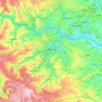
Name: Kirklees topographic map, elevation, terrain.
Location: Kirklees, Yorkshire and the Humber, England, United Kingdom (53.51973 -2.00947 53.76483 -1.57081)
Average elevation: 220 m
Minimum elevation: 28 m
Maximum elevation: 581 m
Other topographic maps
Click on a map to view its topography, its elevation and its terrain.
Kirkburton
United Kingdom > England > Kirklees
Kirkburton, Highburton, Kirklees, West Yorkshire, England, United Kingdom
Average elevation: 148 m
Denby Dale
United Kingdom > England > Kirklees > Scissett
Denby Dale, Scissett, Kirklees, West Yorkshire, England, United Kingdom
Average elevation: 168 m
Gomersal
United Kingdom > England > Kirklees > Gomersal
Gomersal, Kirklees, West Yorkshire, Yorkshire and the Humber, England, BD19 4JR, United Kingdom
Average elevation: 133 m