Geolocate

Raymond topographic map

Click on the map to display elevation.

About this map

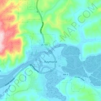
Name: Raymond topographic map, elevation, terrain.

Location: Raymond, Pacific County, Washington, 98577, United States (46.66534 -123.77839 46.71961 -123.70513)

Average elevation: 67 m

Minimum elevation: -12 m

Maximum elevation: 346 m

Other topographic maps

Click on a map to view its topography, its elevation and its terrain.

Gear up for your next adventure:

🧺Waterproof Dry Sacks - Organize your pack and keep electronics safe from rain and river crossings
🧴Sunscreen SPF - Sun protection for outdoor activities
🌧️Rain Jackets - Waterproof jackets for hiking
🥾Heavy Duty Hiking Boots - Ankle-supporting boots for carrying heavy packs on steep contours
Ultralight Solo Tents - Compact shelters for multi-day topographic surveying expeditions

As an Amazon Associate, this site earns from qualifying purchases at no extra cost to you.